Showing posts with label Our World. Show all posts

Tuesday, September 16, 2014

The Sapphire Symbol of Loyalty

It is said it bring Good luck and take envy away from the wearer and it  is  considered a symbol of fidelity in love.
For this reason, the stone is used for the engagement ring.


Monday, September 01, 2014

The frasassi Caves - Le Grotte di Frasassi


The Frasassi Caves, the discovery of which dates back to September 25, 1971 by a group of Ancona CAI Speleological led by Giancarlo Cappanera, are underground karst caves located in the municipality of Genga, in the province of Ancona. The cave complex is located within the Regional Natural Park of Gola della Rossa and Frasassi.

Le Grotte di Frasassi


Le grotte di Frasassi, la cui scoperta risale al 25 settembre 1971 ad opera di un gruppo speleologico del CAI di Ancona guidato da Giancarlo Cappanera, sono delle grotte carsiche sotterranee che si trovano nel territorio del comune di Genga, in provincia di Ancona. Il complesso delle grotte ricade all'interno del Parco naturale regionale della Gola della Rossa e di Frasassi.

Saturday, July 12, 2014

The Hidden Beach of Las Marietas


The Marieta Islands (in Spanish: Islas Marietas) are a group of small uninhabited islands, formed as a result of ancient volcanic activity, which lie few kilometers from the coast of Nayarit, Mexico.

Read more  http://inovemondi.forumfree.it/?t=69140230

Friday, May 02, 2014

XIN ZHUI the Diva Mummy

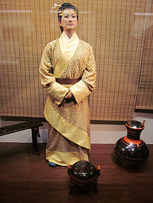
(Artistic reconstruction of Xin Zhui)

Xin Zhui (Chinese: 辛追; pinyin: Xīn Zhuī; died 163 BCE), also known as Lady Dai or Marquise of Dai, was the wife of Li Cang (利蒼), the Marquis of Dai, during the Han Dynasty (206 BCE – 220 CE). She gained fame more than 2,000 years after her death, when her tomb was discovered inside a hill known as Mawangdui, in Changsha, Hunan, China. After opening the tomb, workers discovered her exceptionally preserved remains alongside hundreds of valuable artifacts and documents. Her body and belongings are currently under the care of the Hunan Provincial Museum, which has allowed occasional international exhibits.


Thursday, August 01, 2013

Fairy Chimneys, Cappadocia - Turkey


Cappadocia is a historical region in Central Anatolia, largely in Nevşehir Province, in Turkey.
In the time of Herodotus, the Cappadocians were reported as occupying the whole region from Mount Taurus to the vicinity of the Euxine (Black Sea). Cappadocia, in this sense, was bounded in the south by the chain of the Taurus Mountains that separate it from Cilicia, to the east by the upper

Euphrates and the Armenian Highland, to the north by Pontus, and to the west by Lycaonia and eastern Galatia.
The name was traditionally used in Christian sources throughout history and is still widely used as an international tourism concept to define a region of exceptional natural wonders, in particular characterized by fairy chimneys and a unique historical and cultural heritage.


Cappadocia lies in eastern Anatolia, in the center of what is now Turkey. The relief consists of a high plateau over 1000 m in altitude that is pierced by volcanic peaks, with Mount Erciyes (ancient Argaeus) near Kayseri (ancient Caesarea) being the tallest at 3916 m. The boundaries of historical Cappadocia are vague, particularly towards the west. To the south, the Taurus Mountains form the boundary with Cilicia and separate Cappadocia from the Mediterranean Sea.

To the west, Cappadocia is bounded by the historical regions of Lycaonia to the southwest, and Galatia to the northwest. The Black Sea coastal ranges separate Cappadocia from Pontus and the Black Sea, while to the east Cappadocia is bounded by the upper Euphrates, before that river bends to the southeast to flow into Mesopotamia, and the Armenian Highland. This results in an area approximately 400 km (250 mi) east–west and 250 km (160 mi) north–south. Due to its inland location and high altitude, Cappadocia has a markedly continental climate, with hot dry summers and cold snowy winters. Rainfall is sparse and the region is largely semi-arid.


Cappadocia was known as Hatti in the late Bronze Age, and was the homeland of the Hittite power centred at Hattusa. After the fall of the Hittite Empire, with the decline of the Syro-Cappadocians (Mushki) after their defeat by the Lydian king Croesus in the 6th century, Cappadocia was ruled by a sort of feudal aristocracy, dwelling in strong castles and keeping the peasants in a servile condition, which later made them apt for foreign slavery.

It was included in the third Persian satrapy in the division established by Darius, but continued to be governed by rulers of its own, none apparently supreme over the whole country and all more or less tributaries of the Great King.


Kingdom of Cappadocia

After bringing the Persian Empire to an end, Alexander the Great tried to rule the area through one of his military commanders. But Ariarathes, a Persian aristocrat, somehow became king of the Cappadocians. Ariarathes I (332—322 BC) was a successful ruler, and he extended the borders of the Cappadocian Kingdom as far as to the Black Sea.

The kingdom of Cappadocia lived in peace until the death of Alexander. The previous empire was then divided into many parts, and Cappadocia fell to Eumenes. His claims were made good in 322 BC by the regent Perdiccas, who crucified Ariarathes; but in the dissensions which brought about Eumenes's death, the son of Ariarathes recovered his inheritance and left it to a line of successors, who mostly bore the name of the founder of the dynasty.


Roman and Byzantine province


The Cappadocians, supported by Rome against Mithridates VI of Pontus, elected a native lord, Ariobarzanes, to succeed (93 BC); but in the same year Armenian troops under Tigranes the Great entered Cappadocia, dethroned king Ariobarzanes and crowned Gordios as the new client-king of Cappadocia, thus creating a buffer zone against the encroaching Romans.

It was not until Rome had deposed the Pontic and Armenian kings that the rule of Ariobarzanes was established (63 BC). In the civil wars Cappadocia was first for Pompey, then for Caesar, then for Antony, and finally, Octavian.

The Ariobarzanes dynasty came to an end, a Cappadocian nobleman Archelaus was given the throne, by favour first of Antony and then of Octavian, and maintained tributary independence until AD 17, when the emperor Tiberius, who he had angered, summoned him to Rome and reduced Cappadocia to a Roman province.

Cappadocia contains several underground cities (see Kaymaklı Underground City), largely used by early Christians as hiding places before Christianity became an accepted religion. The underground cities have vast defence networks of traps throughout their many levels.

These traps are very creative, including such devices as large round stones to block doors and holes in the ceiling through which the defenders may drop spears. These defense systems were mainly used against the Romans.


The tunnel system also was made to have thin corridors for the Roman fighting strategy was to move in groups which was not possible to do in the thin corridors making it easy to pick them off. The Cappadocian Fathers of the 4th century were integral to much of early Christian philosophy.

It also produced, among other people, another Patriarch of Constantinople, John of Cappadocia, who held office 517—520. For most of the Byzantine era it remained relatively undisturbed by the conflicts in the area with the Sassanid Empire, but was a vital frontier zone later against the Muslim conquests. From the 7th century, Cappadocia was divided between the Anatolic and Armeniac themes. In the 9th–11th centuries, the region comprised the themes of Charsianon and Cappadocia.

Cappadocia shared an always-changing relationship with neighbouring Armenia, by that time a region of the Empire. The Arab historian Abu Al Faraj asserts the following about Armenian settlers in Sivas, during the 10th century: "Sivas, in Cappadocia, was dominated by the Armenians and their numbers became so many that they became vital members of the imperial armies.
These Armenians were used as watch-posts in strong fortresses, taken from the Arabs. They distinguished themselves as experienced infantry soldiers in the imperial army and were constantly fighting with outstanding courage and success by the side of the Romans in other words Byzantine".


As a result of the Byzantine military campaigns and the Seljuk invasion of Armenia, the Armenians spread into Cappadocia and eastward from Cilicia into the mountainous areas of northern Syria and Mesopotamia, and the Armenian Kingdom of Cilicia was eventually formed.

This immigration was increased further after the decline of the local imperial power and the establishment of the Crusader States following the Fourth Crusade. To the crusaders, Cappadocia was "terra Hermeniorum," the land of the Armenians, due to the large number of Armenians settled there.


Turkish Cappadocia

Following the Battle of Manzikert in 1071, various Turkish clans under the leadership of the Seljuks began settling in Anatolia. With the rise of Turkish power in Anatolia, Cappadocia slowly became a tributary to the Turkish states that were established to the east and to the west; some of the population converted to Islam but the main Greek-Byzantine population moved to the Ionian coast.

By the end of the early 12th century, Anatolian Seljuks had established their sole dominance over the region. With the decline and the fall of the Konya-based Seljuks in the second half of the 13th century, they were gradually replaced by the Karaman-based Beylik of Karaman, who themselves were gradually succeeded by the Ottoman Empire over the course of the 15th century.


Cappadocia remained part of the Ottoman Empire for the centuries to come, and remains now part of the modern state of Turkey. A fundamental change occurred in between when a new urban center, Nevşehir, was founded in the early 18th century by a grand vizier who was a native of the locality (Nevşehirli Damat İbrahim Pasha), to serve as regional capital, a role the city continues to assume to this day.


In the meantime many former Cappadocians had shifted to a Turkish dialect (written in Greek alphabet, Karamanlıca), and where the Greek language was maintained (Sille, villages near Kayseri, Pharasa town and other nearby villages), it became heavily influenced by the surrounding Turkish. This dialect of Greek is known as Cappadocian Greek. Following the 1923 population exchange between Greece and Turkey, the language is now only spoken by a handful of the former population's descendants in modern Greece.


Modern tourism

The area is a popular tourist destination, as it has many areas with unique geological, historic, and cultural features.
The region is located southwest of the major city Kayseri, which has airline and railway service to Ankara and Istanbul.

The most important towns and destinations in Cappadocia are Urgup, Goreme, Ihlara Valley, Selime, Guzelyurt, Uchisar, Avanos and Zelve. Among the underground cities worth seeing are Derinkuyu, Kaymakli, Gaziemir and Ozkanak. The best historic mansions and cave houses for tourist stays are in Urgup, Goreme, Guzelyurt and Uchisar.


Hot-air ballooning is very popular in Cappadocia and is available in Goreme. Trekking is enjoyed in Ihlara Valley, Monastery Valley (Guzelyurt), Urgup and Goreme.
Sedimentary rocks formed in lakes and streams and ignimbrite deposits that erupted from ancient volcanoes approximately 9 to 3 million years ago, during the late Miocene to Pliocene epochs, underlie the Cappadocia region. The rocks of Cappadocia near Göreme eroded into hundreds of spectacular pillars and minaret-like forms. People of the villages at the heart of the Cappadocia Region carved out houses, churches and monasteries from the soft rocks of volcanic deposits. Göreme became a monastic centre in 300—1200 AD.


The first period of settlement in Göreme goes back to the Roman period. The Yusuf Koç, Ortahane, Durmus Kadir and Bezirhane churches in Göreme, and houses and churches carved into rocks in the Uzundere, Bağıldere and Zemi Valleys all illustrate history and can be seen today. The Göreme Open Air Museum is the most visited site of the monastic communities in Cappadocia (see Churches of Göreme, Turkey) and is one of the most famous sites in central Turkey.

The complex contains more than 30 carved-from-rock churches and chapels, some having superb frescoes inside, dating from the 9th century to the 11th century.

Cappadocia UNESCO World Heritage Site


Source: http://en.wikipedia.org/wiki/Cappadocia


Tuesday, July 02, 2013

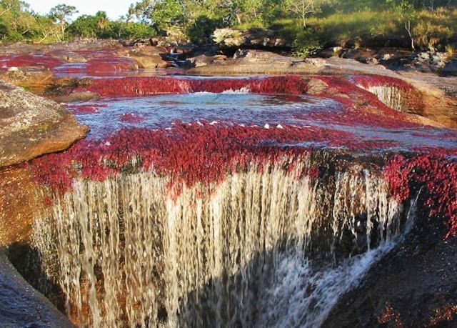
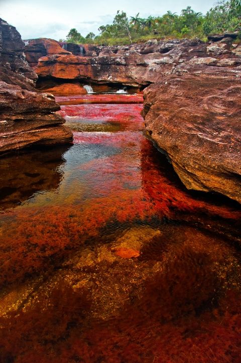
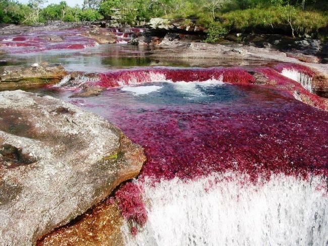
"The River of Five Colors" - Caño Cristales


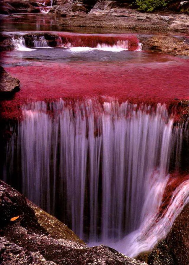
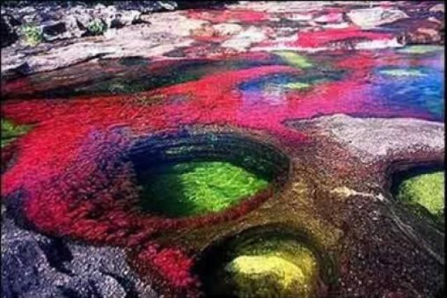
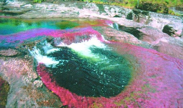
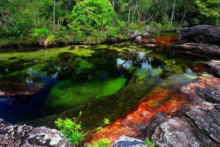
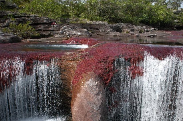
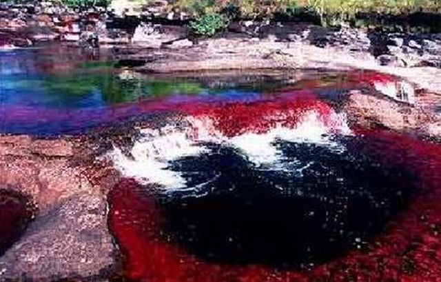
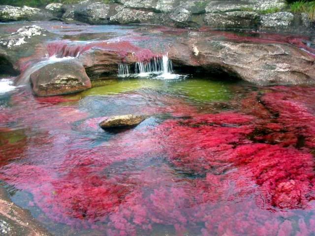
Caño Cristales is a Colombian river located in the Serrania de la Macarena, province of Meta. The river is commonly called "The River of Five Colors," "The Liquid Rainbow" or even "The Most Beautiful River in the World" due to the striking colors like yellow, green, blue, black, and especially the red of the Macarenia clavigera at the bottom of the river giving it a unique appearance.
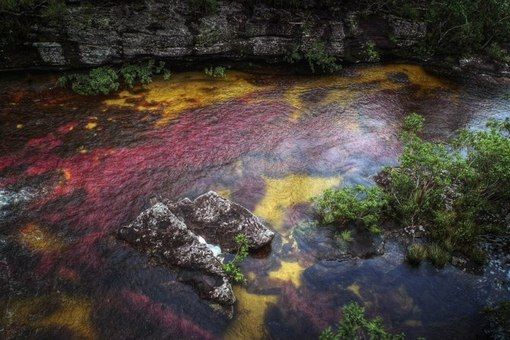
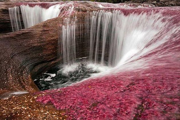


A unique biological wonder, Caño Cristales has been referred as the "river of five colors," "the river that ran away from paradise," and "the world's most beautiful river."
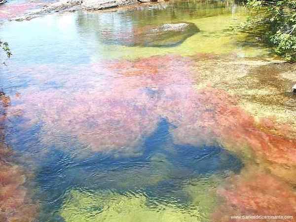
For most of the year, Caño Cristales is indistinguishable from any other river: a bed of rocks covered in dull green mosses are visible below a cool, clear current.
However, for a brief period of time every year, the river blossoms in a vibrant explosion of colors. During the short span between the wet and dry seasons, when the water level is just right, a unique species of plant that lines the river floor called Macarenia clavigera turns a brilliant red. It is offset by splotches of yellow and green sand, blue water, and a thousand shades in between.


This only happens for a brief period in between seasons. During Colombia's wet season, the water flows too fast and deep, obscuring the bottom of the river and denying the Macarenia clavigera the sun that it needs to turn red. During the dry season there is not enough water to support the dazzling array of life in the river. But for a few weeks from September through November, the river transforms into a veritable living rainbow.

Caño Cristales is located in a remote, isolated area not easily accessible by road. Adventurous tourists can now fly into the nearby town of La Macarena. From there it is a short trip into "Serrania de la Macarena," the national park in which Caño Cristales is located.


It is a succession of rapids, waterfalls, correones and pocetas whose waters flow from the plateau south of the Serranía de la Macarena, where this birth, behind the oldest tepuis of the Sierra in a rugged area in which numerous rock paintings are still unexplored.

The site was effectively closed to tourists for several years because of guerrilla activity in the region along with concerns about the impact of unregulated tourist traffic. It was reopened to visitors in 2009, and today there are several Colombian Tourist Agencies that will fly travelers to La Macarena. From there, they must make their way to the river site on horseback (or donkeyback) and by foot as part of a guided tour. Visitors are not permitted to stay overnight or cook.

The rocks of the Macarena reach 1200 million years old and are an extension to the west of the called Guiana Shield of Venezuela, Guyana and Brazil, whose rocks are considered the oldest in the world. The rocks of the region belong to the sedimentary cover of the Guaiana Shield.

The biological significance of global of the Macarena is because part of three ecosystems rich in diversity of flora and fauna: Andes, Eastern Llanos and Amazon rainforest. "Every new germs gap rush stations", says José Eustasio Rivera in La Vorágine, referring to this type of vegetation.
In the jungle of the Macarena struggle for nutrients for the soil to populate various fungi that help break down the trunks of trees.


The small circular pits, -giant's kettle- that characterize the river bed have been opened by high hardness minerals. When one of these hard mineral fragments falls into one of the cavities, large or small, begins to brushing rotate with the cavity wall and increases the dimensions of the well.

Caño Cristales has aquatic plants and corals. Its red color is characteristic of endemic plant species corresponds to Macarenia clavígera, plant identified by biologist Jesús Idrobo.

The biome representative of the Serranía de La Macarena is the rainforest subhydrophytic of the thermal floor hot, warm and cold. The mountain is home to about 420 species of birds, ten species of amphibians, 43 species of reptiles and eight primates.

However, the river is totally devoid of fish due to its lack of drag and sedimentation materials. Other channels of the Macarena, also hold red plants in winter, as the Caño Siete Machos. These red plants adhere tightly to rocks in places where the river has more stream.
It is not known what activities can be done in such rivers.


To reach Caño Cristales, it is necessary to travel to the municipality of La Macarena, Meta, in Meta Department. There are two ways to get from Villavicencio, in a DC3 Cargo aircraft coming out every day, or from Bogota, in direct flight that departs every Friday and return on Sunday. Presently, there are no camp sites available near Caño Cristales.
The most ideal months to visit Caño Cristales are from late July to early December.


Source: http://en.wikipedia.org/wiki/Ca%C3%B1o_Cristales


Versione Italiana:

http://inovemondi.forumfree.it/?t=66192793


Monday, June 17, 2013

The Catacombs of Paris


The Catacombs of Paris or Catacombes de Paris is an underground ossuary in Paris, France. Located south of the former city gate (the "Barrière d'Enfer" at today's Place Denfert-Rochereau), the ossuary holds the remains of about six million people and fills a renovated section of caverns and tunnels that are the remains of Paris's stone mines.

Opened in the late 18th century, the underground cemetery became a tourist attraction on a small scale from the early 19th century, and has been open to the public on a regular basis from 1874. Following an incident of vandalism, they were closed to the public in September 2009 and reopened 19 December of the same year.


In the entrance there is a stone portal, the ossuary entry, with the inscription:

Arrête! C'est ici l'empire de la Mort ('Stop! Here lies the Empire of Death").


The Catacombs are one of the 14 City of Paris' Museums that have been incorporated since January 1st 2013 in the public institution Paris Musées.
The official name for the catacombs is l'Ossuaire Municipal.

Although this cemetery covers only a small section of underground tunnels comprising "les carrières de Paris" ("the quarries of Paris"), Parisians today often refer to the entire tunnel network as "the catacombs".


Since Roman times, Paris has buried its dead on the outskirts of the city, but habits changed with the rise of Christianity and its practice of burying its faithful in the consecrated ground under and around its churches, no matter their location.

By the 10th century, many of Paris's parish cemeteries were well within city limits, and eventually some, because of their central location in dense urban growth, were unable to expand and became overcrowded. An attempt to remedy this situation came in the early 12th century with the opening of a central mass burial ground for those not wealthy enough to pay for a church burial.

Depending on the St. Opportune church near Paris's central Les Halles district, this cemetery had its own Saints Innocents church and parish appellation by the end of the same century. Eventually, Paris's other churches adopted the technique of mass inhumation as well.

Once an excavation in one section of the cemetery was full, it would be covered over and another opened. Residues resulting from the decaying of organic matter, a process often chemically accelerated with the use of lime, entered directly into the earth, creating a situation unacceptable for a city whose then-principal source of water was wells.


As it was one of Paris's most sought-after cemeteries and a large source of revenue for the parish and church, the clergy had continued burials there even when its grounds were filled to overflowing. By then, the cemetery was lined on all four sides with "charniers" reserved for the bones of the dead exhumed from mass graves that had "lain" long enough for all the flesh they contained to decompose.

Once emptied, a mass sepulchre would be used again, but even then, the earth was already filled beyond saturation with decomposing human remains.
A series of ineffective decrees limiting the use of the cemetery did little to remedy the situation, and it wasn't until the late 18th century that it was decided to create three new large-scale suburban burial grounds on the outskirts of the city, and to condemn all existing parish cemeteries within city limits.

The new cemeteries were created outside the central area of the capital, in the early 19th century: Montmartre Cemetery in the north, Père Lachaise Cemetery in the east, Passy Cemetery in the west. Later, Montparnasse Cemetery was added in the south.


The government had been searching for and consolidating long abandoned stone quarries in and around the capital since 1777, and it was the Police Lieutenant General overseeing the renovations, Alexandre Lenoir, who first had the idea to use empty underground tunnels on the outskirts of the capital to this end.

His successor, Thiroux de Crosne, chose a place to the south of Paris's "porte d'Enfer" city gate (the place Denfert-Rochereau today), and the exhumation and transfer of all Paris's dead to the underground sepulture began in 1786, taking until 1788 to complete.


From the eve of a consecration ceremony on the 7th April the same year, behind a procession of chanting priests, began a parade of black-covered bone-laden horse-drawn wagons that continued for years.

In work overseen by the Inspector General of Quarries, Charles-Axel Guillaumot, the bones were deposited in a wide well dug in land bought from a property, "La maison de la Tombe Issoire" (near a house with the same name), and distributed throughout the underground caverns by workers below. Also deposited near the same house were crosses, urns and other necropolis memorabilia recovered from Paris's church graveyards.

The catacombs in their first years were mainly a bone repository, but Guillaumot's successor from 1810, Louis-Étienne Héricart de Thury, oversaw the renovations that would transform the underground caverns into a real and visitable sepulture on par with any mausoleum.

In addition to directing the arrangement of skulls and femurs into the configuration seen in the catacombs today, he used those tombstones and cemetery decorations he could find (many had disappeared after the 1789 Revolution) to complement the walls of bones.


The Catacombs entry is in the western pavilion of Paris's former Barrière d'Enfer city gate. After descending a narrow spiral stone stairwell of 19 meters to the darkness and silence broken only by the gurgling of a hidden aqueduct channeling local springs away from the area, and after passing through a long (about 1.5 km) and twisting hallway of mortared stone, visitors find themselves before a sculpture that existed from a time before this part of the mines became an ossuary, a model of France's Port-Mahon fortress created by a former Quarry Inspector.

Beyond begin the halls and caverns of walls of carefully arranged bones. Some of the arrangements are almost artistic in nature, such as a heart-shaped outline in one wall formed with skulls embedded in surrounding tibias; another is a round room whose central pillar is also a carefully created 'keg' bone arrangement.

Along the way one would find other 'monuments' created in the years before catacomb renovations, such as a source-gathering fountain baptised "La Samaritaine" because of later-added engravings. There are also rusty gates blocking passages leading to other 'unvisitable' parts of the catacombs – many of these are either un-renovated or were too un-navigable for regular tours.


Bodies of the dead from the riots in the Place de Grève, the Hôtel de Brienne, and Rue Meslée were put in the catacombs on 28 and 29 August 1788.
The tomb of the Val-de-Grâce hospital doorkeeper, Philibert Aspairt, lost in the catacombs in 1793 and found 11 years later, is located in the catacombs on the spot where his body was found.

The catacomb walls are covered in graffiti dating from the eighteenth century onwards. Victor Hugo used his knowledge about the tunnel system in Les Misérables. In 1871, communards killed a group of monarchists in one chamber. During World War II, Parisian members of the French Resistance used the tunnel system.

Also during this period, German soldiers established an underground bunker in the catacombs below Lycée Montaigne, a high school in the 6th arrondissement.

Although the catacombs offered space to bury the dead, they presented disadvantages to building structures; because the catacombs are right under the Paris streets, large foundations cannot be built. For this reason, there are not many tall buildings in this area of Paris.


Source: http://en.wikipedia.org/wiki/Catacombs_of_Paris